Perfect Storm Anniversery
Posted by JAC on 10/30/2009, 7:44 am
| http://en.wikipedia.org/wiki/Perfect_storm http://www.ncdc.noaa.gov/oa/satellite/satelliteseye/cyclones/pfctstorm91/pfctstorm.html 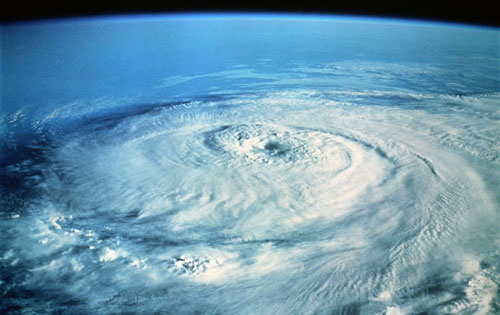 Stu Ostro, Senior Meteorologist http://www.weather.com/multimedia/videoplayer.html?clip=15625  Today marks the anniversary of the peak of what for awhile was known as the "Halloween Storm," until Bob Case of the National Weather Service coined it "The Perfect Storm," and then came the book & movie which chronicled the plight of the Andrea Gail and escalated this weather event's legacy into popular culture. With Jim Cantore reporting live today from Gloucester, Massachusetts and The Weather Channel airing The Perfect Storm tonight, I'm reproducing here the blog entry I posted on the 15th anniversary in 2006. And while I'm at it, here are links to a great sequence of satellite images showing the life cycle of the storm and an animation of the evolution at the surface and aloft. Mr. Case was not engaging in hyperbole. This was truly an extraordinary confluence of atmospheric ingredients. Although other East Coast cyclones (e.g. hurricanes and snowstorms) have been "worse" in terms of severity of wind and precipitation, and overall impact to people and/or property, this one was unique in its evolution, and per these NCDC and NWS reports it was no slouch in its atmospheric and oceanic statistics either. And of course there were the tragedies at sea for which the storm is [in]famous. For all of these reasons, the event is more well-known than some of those in recent decades which have made the official billion dollar disaster list (this one's cost was in the hundreds of millions of dollars). IT ALL BEGAN ... ... on the 28th and 29th of October 1991 with a cold front and burgeoning non-tropical storm over the northwest Atlantic eating Hurricane Grace for breakfast. We'll never know exactly what the outcome would have been without Grace; the situation was already potent, but the hurricane did play a key role by providing extra moisture and energy and influencing the overall configuration of weather systems. Meanwhile, there was also a strong high pressure system over eastern Canada to the northwest of the developing storm which helped develop a steep "pressure gradient" and long fetch of wind. This already caused waves to build, and it was during this phase that the Andrea Gail met its fate. (The exact time of the vessel's and its crew's loss is unknown but the final reported contact was on the 28th). Ultimately the developing storm became quite a formidable one in strength and a behemoth in size, and it backed toward the U.S. coast rather than move away as most storms which are already at sea do. The most significant impacts on land were felt in the northeast U.S. where damage was widespread, including, as you might recall, to then-President George H. W. Bush's house in Kennebunkport, Maine, but effects in the form of high waves were felt all the way from Newfoundland to Puerto Rico. Although the storm was officially "extratropical" at its peak and it certainly did have non-tropical aspects, near its center the cyclone also had some characteristics of a tropical or at least subtropical cyclone. There's no problem finding satellite imagery of The Perfect Storm on the web but it's not so easy to find radar. Check out the image below, a screen shot from TWC's coverage that evening, as the storm moved westward near southeast New England. Sure looks like an eyewall on the north side of the center, doesn't it? (The south "eyewall" may have been too far away from the radar to show up, or the rain might have not completely surrounded the center.) After whacking the coast on October 30 -- its estimated lowest pressure of 972 millibars was that day and its closest approach to land was that night -- the storm rapidly wound down on Halloween itself. However, in a bizarre (yet fitting) final chapter ... Within the weakening larger overall circulation, a small circulation (see below) that was decidedly "warm-core," indicative of a tropical cyclone, spun up on November 1 and became an unnamed hurricane!  Thus, the "unnamed hurricane" wasn't The Perfect Storm per se, it was only a piece of the entire evolution of the event, and one which did not produce any of the significant damage. The hurricane was not named because it was feared that would confuse people. Given how bad the original storm was, there was the potential for undue alarm if residents along the coast heard a hurricane with a traditional "name" had now developed. But ironically the hurricane was so tiny that it was relatively harmless, especially given that it was heading away from the U.S. coast, not toward it like the parent storm a couple days prior. Landfall was eventually made, but as a rapidly waning tropical storm in Nova Scotia on November 2 with little impact. A non-tropical system absorbing a tropical one is not unprecedented, nor is a tropical cyclone developing from a non-tropical system. But for both processes to occur with the same system, not to mention one of this magnitude, is what made the cyclone so amazing. To me, this was the ultimate "hybrid" storm. [ADDITIONAL NOTE 11/6/2006: I had forgotten about this, but Grace itself started as a subtropical storm ... so this event is even more of an ultimate hybrid than I realized when I originally posted the entry!] MEMORIES ... I have vivid memories of that whole situation as it unfolded. I had been at The Weather Channel for only a couple of years, and was in the midst of a few days off. Upon briefly stopping by the office to attend a meeting, my colleague Tony Fulkerson, who was working the shift on the other side of the week, popped his head in the room and said, "Stu, have you looked at the weather situation?" Upon doing so shortly thereafter, I thought, "Oh, my!" Next thing I knew, I found myself on the air the following evening, with Jeff Morrow, whom I've known for -- gasp! we're not as young as we once were! -- 30 years now since our first math class together in our freshman year in college. This was the second weather event during which I made cameo appearances. The first was Hurricane Bob a couple months prior. The next ones after The Perfect Storm included Hurricane Andrew and the severe nor'easter in December 1992, then the Superstorm in March 1993 [video clip of that is here]. Ahh, those were the days ... And, as much as it makes me wince to go back and look (for example, my oversized eyeglasses were not quite ready for prime time!), below is a screen shot and video of one of the segments that evening. I can't definitively lay claim to that being the first time water vapor imagery was ever shown on television because I don't know for sure what else might have taken place before that, but at least to the best of my knowledge it was the first time on TWC and perhaps elsewhere. In any event, I couldn't resist displaying and talking about that water vapor loop, as it seemed if ever there was a time to spring it on the masses, this was it -- what a sight! THE OTHER STORM I'd be remiss if I didn't mention the forgotten storm that was happening at the same time (October 31 - November 2, 1991). Forgotten in the sense of not receiving the notoriety of its cousin to the east, but long-remembered by those who were there at the time. Portions of the Midwest were being affected by another powerful cyclone and an unusually cold arctic outbreak for so early in the season, the combination of which which resulted in an extreme early-season snowstorm. It was dubbed by some the "Great Halloween Megastorm" and set the record for the largest single-storm snowfall (28.4") in Minneapolis history for any month of the year! Likewise, the 37.9" snowfall in Duluth was the largest on record for the state of Minnesota, beating any storm in the middle of winter. On the southern fringe of the wintry precipitation was a severe ice storm in Iowa. And the two atmospheric explosions were connected, as can be seen by the pattern aloft (first map below): a big-time "trough" over all of western North America with a strong disturbance about to swing from the southwest U.S. toward the Great Lakes, which led to the intense cyclone centered near Lake Superior a few days later (second map below, and note the relatively benign unnamed tropical storm in Nova Scotia); a mammoth cutoff low in the western Atlantic, associated with the Perfect Storm which was blocked from a rapid exit out to sea; and a ridge in between waaay up across eastern Canada.   The Halloween Blizzard of 1991 was an early-season storm that moved north from the Gulf of Mexico to the upper Great Lakes. Unseasonably cold air allowed the rich moisture-laden airmass to deposit a long band of snow from the Panhandle of Texas northeastward to western Lake Superior. Many early-season snow total records were broken, and single-storm records fell at Minneapolis (28.4) and Duluth (36.9) Typically storms from the Gulf of Mexico do not move due north; however, eastward motion of this system was blocked by a large nor'easter off the coast of New England (the so-called "Perfect Storm"). In the visible loop above, notice the rapid melting of snow deposited by the system in west-central Texas, despite record cold (30 and 31 October 1991 are the only October days in Amarillo history that stayed below 30 all day) Snowcover in South Dakota (The Missouri River stands out) also speaks to the chill in the airmass on the cold side of the storm. |
107
In this thread:
Perfect Storm Anniversery - JAC, 10/30/2009, 7:44 am
- Re: Perfect Storm Anniversery - freesong, 10/30/2009, 10:13 am
- Re: Perfect Storm Anniversery - Fred, 10/30/2009, 8:17 am
- Re: Perfect Storm Anniversery - JAC, 10/30/2009, 8:42 am
< Return to the front page of the: message board | monthly archive this page is in
Post A Reply
This thread has been archived and can no longer receive replies.