After the Blizzard
Posted by
JAC on 12/13/2009, 12:19 pm
Last week, a powerful blizzard paralyzed parts of the US midwest. Mike Hollingshead of Blair, Nebraska, walked outside after the storm and this is what he saw:
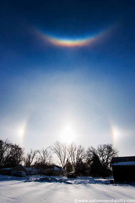
Sunlight shining through ice crystals had produced a bright pair of sundogs and a vivid circumzenithal arc.
"These tend to appear on the backside of a storm's clearing line as ice crystals blow through the air," notes Hollingshead.
"It's a beautiful sight but not a ton of fun to photograph at 5o F with winds blowing 40 mph."

MODIS true color and false color images from the SSEC MODIS Today site on 11 December 2009 (above) showed a nice view of the snow cover following the blizzard of 08 December - 09 December 2009.
On the false color image, snow appears as shades of cyan (in contrast to supercooled water droplet clouds, which appear as brighter white features).
The maximum snow depths across the region at the time of these MODIS images included 32 inches in the Upper Peninsula of Michigan,
18 inches in southern Wisconsin,
17 inches in northern Lower Michigan,
16 inches in Iowa,
12 inches in southern Minnesota, and
10 inches in northern Illinois.
Besides the large lake-effect cloud bands streaming across Lake Superior and Lake Michigan,
some other interesting features to note are the smaller lake-effect cloud plumes streaming eastward off the many still-unfrozen lakes in southern Ontario, Canada (northwest of Lake Superior),
and also the narrow streaks of snow on the ground across parts of Illinois and Indiana (south of Lake Michigan).
|
56
In this thread:
After the Blizzard - JAC, 12/13/2009, 12:19 pm Post A Reply
This thread has been archived and can no longer receive replies.