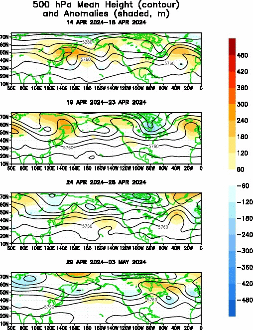
The Rex Block
Posted by JAC on 1/7/2010, 7:14 am
64
In this thread:
Global What? Widespread severe cold makes people wonder about climate - JAC, 1/7/2010, 7:01 am
- Re: Global What? Widespread severe cold makes people wonder about climate - Conclue, 1/8/2010, 8:26 pm
- Re: Global What? Widespread severe cold makes people wonder about climate - Conclue, 1/8/2010, 8:27 pm
- Snow pack to N GA and Mid AL - JAC, 1/8/2010, 11:13 am
- Arguably, one of the largest contributors to global warming - JAC, 1/8/2010, 8:07 am
- Re: Global What? Widespread severe cold makes people wonder about climate - hanna, 1/7/2010, 8:35 pm
- Re: Global What? Widespread severe cold makes people wonder about climate - JAC, 1/8/2010, 6:47 am
- Re: Global What? Widespread severe cold makes people wonder about climate - hanna, 1/8/2010, 10:28 am
- Re: Global What? Widespread severe cold makes people wonder about climate - JAC, 1/8/2010, 6:47 am
- Re: Global What? Widespread severe cold makes people wonder about climate - jimw, 1/7/2010, 1:26 pm
- Re: Global What? Widespread severe cold makes people wonder about climate - Conclue, 1/7/2010, 9:56 pm
- Re: Global What? Widespread severe cold makes people wonder about climate - Gianmarc, 1/7/2010, 8:41 am
- Need to really look at the anomalies averaged over a period of time - JAC, 1/7/2010, 9:07 am
- Re: Global What? Widespread severe cold makes people wonder about climate - JAC, 1/7/2010, 8:59 am
- Current Midwest Surface-Low - JAC, 1/7/2010, 8:15 am
- rex block question - sandy, 1/8/2010, 4:50 am
- Re: rex block question - JAC, 1/8/2010, 6:43 am
- rex block question - sandy, 1/8/2010, 4:50 am
- Current Midwest Surface-Low - JAC, 1/7/2010, 8:15 am
Post A Reply
This thread has been archived and can no longer receive replies.