A Strong Jet and High Theta-E Air is a Deadly Combo when a Cold-Front Approaches.
Posted by JAC on 4/26/2010, 12:04 pm
  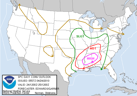 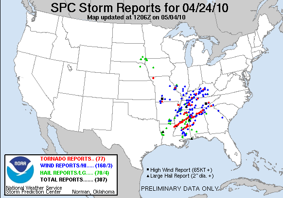 On a rare "High Risk" SPC Convective Outlook day, a significant tornado outbreak occurred across the Deep South region of the US on 24 April 2010 which produced long-track tornadoes that were responsible for at least 10 fatalities across parts of Mississippi (SPC storm reports | NWS Jackson MS event summary). http://www.spc.noaa.gov/climo/reports/100424_rpts.html http://www.srh.noaa.gov/jan/?n=2010_04_24_tor_overview AWIPS images of the GOES-13 6.5 m water vapor channel data with overlays of surface fronts (above) showed a cold frontal boundary advancing eastward across the region, with a strong punch of dry air aloft associated with an upper level jet stream.  The NAM model fields suggested that the maximum winds within the jet core were in the 140-145 knot range, but there were a number of MADIS 1-hour interval atmospheric motion vectors with speeds of 155-157 knots along the sharp dry-to-moist water vapor gradient. Widespread cloudiness obstructed a good view of the amount of Total Precipitable Water (TPW) that was available using the GOES Sounder or MODIS, but the Blended Total Precipitable Water product (below) showed that TPW values of 40 - 50 mm (red to violet color enhancement) were in place within the warm sector ahead of the cold front.    An animation of GOES-13 10.7 m IR images (below) revealed that the cluster of severe convection appeared to intensify as it crossed the Mississippi River from Louisiana into Mississippi after about 16 UTC. While there was not the typical "enhanced-v" storm top signature that is often seen with severe convection, the GOES-13 IR cloud top brightness temperatures did cool to -60 C and below (darker red color enhancement) after 13:40 UTC, reaching a minimum value of -63 C at 18:32 UTC. Closer views of the IR imagery showed that these storms were characterized by a great deal of cloud to ground lightning strikes as they produced a number of tornado and damaging wind reports.   Farther to the north, there was a report of softball-size hail (4.5 inches in diameter) in western Tennessee at 21:00 UTC.  A comparison of a 1-km resolution MODIS 11.0 m IR image with the corresponding 4-km resolution GOES-13 10.7 m IR image as the core of the storm was crossing the Mississippi River around 16:30 UTC (below) demonstrates (1) the improvement in accuracy of storm top brightness temperature detection with higher spatial resolution (-69 C with MODIS, versus -58 C with GOES), and (2) the "parallax shift" associated with the relatively large geostationary satellite view angle (note that the storm features are shifted a bit to the northwest on the GOES-13 image). The SPC storm reports of tornadoes and damaging winds within the 16:14 - 17:55 UTC time range are also plotted on the two IR images.  A similar AVHRR 10.8 m IR image at 18:40 UTC with an overlay of SPC severe reports can be seen here.  |
53
In this thread:
A Strong Jet and High Theta-E Air is a Deadly Combo when a Cold-Front Approaches. - JAC, 4/26/2010, 12:04 pm
- 149-mile Tornado Track - JAC, 4/27/2010, 6:23 am
- How High Does a Tornado Go? - JAC, 4/26/2010, 12:36 pm
- Damage Path: Before and After - JAC, 4/26/2010, 12:26 pm
< Return to the front page of the: message board | monthly archive this page is in
Post A Reply
This thread has been archived and can no longer receive replies.