ENSO Quick Look & Discussion, etc...
Posted by cypresstx on 10/6/2012, 3:24 pm
still neutral at .3  historical historical so. might there be some "hangers-on" in the Atlantic in Nov?  Oscar went away as quickly as he formed, now we have a yellow circle in the Bahamas, but it's only at 10%... Oscar went away as quickly as he formed, now we have a yellow circle in the Bahamas, but it's only at 10%...  FSU has 97L at 19% atm... not sure if that's contaminated by GOES-13's issues or not ?  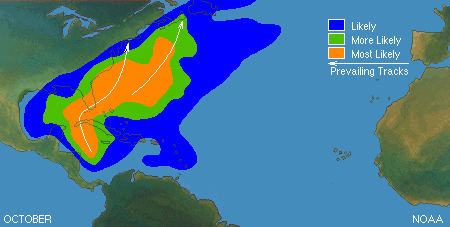 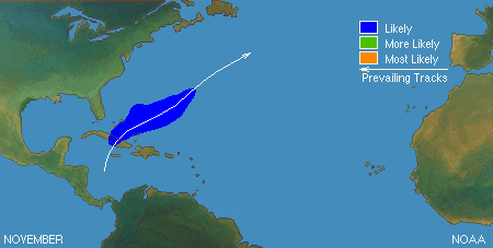  http://iri.columbia.edu/climate/ENSO/currentinfo/QuickLook.html  http://iri.columbia.edu/climate/ENSO/currentinfo/update.html CPC/IRI ENSO Update 04 October 2012 El Niño/Southern Oscillation (ENSO) Diagnostic Discussion issued jointly by the Climate Prediction Center/NCEP/NWS and the International Research Institute for Climate and Society ENSO Alert System Status: El Niño Watch Synopsis: Borderline ENSO-neutral/ weak El Niño conditions are expected to continue into Northern Hemisphere winter 2012-13, possibly strengthening during the next few months During September 2012, the trend towards El Niño slowed in several key oceanic and atmospheric indicators. However, the Pacific basin reflects borderline ENSO-neutral/ weak El Niño conditions. Equatorial sea surface temperatures (SST) remained elevated across the Pacific Ocean (Fig. 1), although anomalies decreased during the month as indicated by weekly index values in the Niño regions (Fig. 2). The oceanic heat content (average temperature in the upper 300m of the ocean) anomalies also weakened (Fig. 3), but continued to show large regions of above-average temperatures at depth across the equatorial Pacific (Fig. 4). Interestingly, low-level westerly wind anomalies were evident over the equatorial western Pacific Ocean (Fig. 5), which may portend possible strengthening of the subsurface anomalies in the coming months. Despite these winds, the atmosphere was still largely ENSO-neutral, as reflected by the Southern Oscillation index and near-average upper-level and lower-level winds across much of the Pacific. Tropical convection increased near the Date Line, which is consistent with weak El Niño conditions, but also remained elevated over eastern Indonesia, which is further westward than expected (Fig. 6). Thus, the atmosphere and ocean indicate borderline ENSO-neutral/ weak El Niño conditions. Compared to the past few months, the chance is reduced for El Niño to develop during Northern Hemisphere fall/winter 2012-13 (see CPC/IRI consensus forecast). Due to the recent slowdown in the development of El Nino, it is not clear whether a fully coupled El Niño will emerge. The majority of models indicate that borderline ENSO-neutral/ weak El Niño conditions will continue, and about half suggest that El Niño could develop, but remain weak (Fig. 7). The official forecast therefore favors the continuation of borderline ENSO-neutral/ weak El Niño conditions into Northern Hemisphere winter 2012-13, with the possibility of strengthening during the next few months. |
180
In this thread:
ENSO Quick Look & Discussion, etc... - cypresstx, 10/6/2012, 3:24 pm
- Re: ENSO Quick Look & Discussion, etc... - freesong, 10/6/2012, 7:04 pm
- Re: ENSO Quick Look & Discussion, etc... - hanna, 10/7/2012, 10:31 am
< Return to the front page of the: message board | monthly archive this page is in
Post A Reply
This thread has been archived and can no longer receive replies.