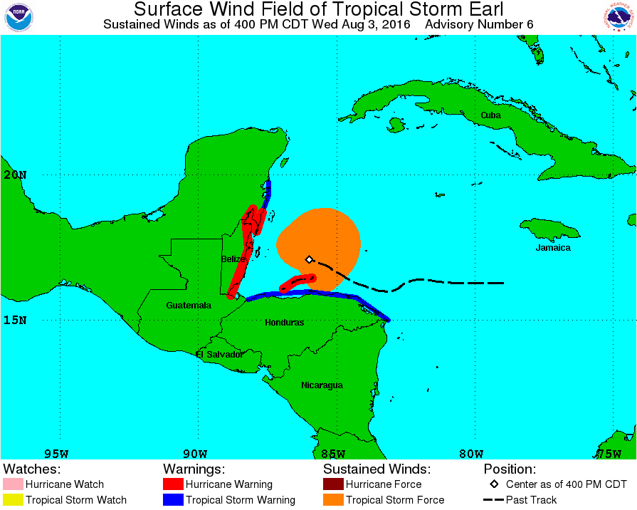
4PM - wind field expanding
Posted by cypresstx on 8/3/2016, 4:43 pm

71
In this thread:
eye on rapid scan - cypresstx, 8/3/2016, 4:22 pm
- Recon Image - Chris in Tampa, 8/3/2016, 9:46 pm
- center is really popping - cypresstx, 8/3/2016, 10:08 pm
- Re: center is really popping - Chris in Tampa, 8/3/2016, 10:36 pm
- Re: center is really popping - Chris in Tampa, 8/3/2016, 10:46 pm
- Sustained tropical storm force winds have arrived - Hurricane force wind arriving soon - tvsteve, 8/3/2016, 11:09 pm
- Re: Sustained tropical storm force winds have arrived - Hurricane force wind arriving soon - Chris in Tampa, 8/3/2016, 11:20 pm
- Re: Sustained tropical storm force winds have arrived - Hurricane force wind arriving soon - tvsteve, 8/4/2016, 12:28 am
- Re: Sustained tropical storm force winds have arrived - Hurricane force wind arriving soon - Chris in Tampa, 8/4/2016, 1:04 am
- Re: Sustained tropical storm force winds have arrived - Hurricane force wind arriving soon - tvsteve, 8/4/2016, 12:28 am
- Re: Sustained tropical storm force winds have arrived - Hurricane force wind arriving soon - Chris in Tampa, 8/3/2016, 11:20 pm
- Sustained tropical storm force winds have arrived - Hurricane force wind arriving soon - tvsteve, 8/3/2016, 11:09 pm
- Re: center is really popping - Chris in Tampa, 8/3/2016, 10:46 pm
- Re: center is really popping - Chris in Tampa, 8/3/2016, 10:36 pm
- center is really popping - cypresstx, 8/3/2016, 10:08 pm
- Re: 4PM - wind field expanding - weatherwizard, 8/3/2016, 5:26 pm
- way cool Chris - cypresstx, 8/3/2016, 5:50 pm
- Re: way cool Chris - Chris in Tampa, 8/3/2016, 6:05 pm
- Radar loop - Chris in Tampa, 8/3/2016, 7:21 pm
- Re: Radar loop - freesong, 8/3/2016, 11:01 pm
- awesome, tks ! - cypresstx, 8/3/2016, 8:20 pm
- Re: awesome, tks ! - Chris in Tampa, 8/3/2016, 8:30 pm
- Re: awesome, tks ! - Chris in Tampa, 8/3/2016, 8:33 pm
- Re: awesome, tks ! - Chris in Tampa, 8/3/2016, 8:51 pm
- Re: awesome, tks ! - Chris in Tampa, 8/3/2016, 8:33 pm
- Re: awesome, tks ! - Chris in Tampa, 8/3/2016, 8:30 pm
- Radar loop - Chris in Tampa, 8/3/2016, 7:21 pm
- Re: way cool Chris - Chris in Tampa, 8/3/2016, 6:05 pm
- Re: 4PM - wind field expanding - jimw, 8/3/2016, 5:48 pm
- Belize radar loop - cypresstx, 8/3/2016, 6:05 pm
- Re: Belize radar loop - Chris in Tampa, 8/3/2016, 6:10 pm
- Belize radar loop - cypresstx, 8/3/2016, 6:05 pm
- way cool Chris - cypresstx, 8/3/2016, 5:50 pm
- Re: 4PM - wind field expanding - weatherwizard, 8/3/2016, 5:26 pm
Post A Reply
This thread has been archived and can no longer receive replies.