Models Honing in on CV Wave
Posted by JAC on 7/12/2010, 10:09 am


272
In this thread:
- Re: Models Honing in on CV Wave - BobbiStorm, 7/13/2010, 9:31 am
- SAL Cleared Out to 35W - JAC, 7/13/2010, 10:44 am
- Large, High Cloud-Top MCS Hitting the Water - JAC, 7/13/2010, 6:51 am
- Re: Large, High Cloud-Top MCS Hitting the Water - BobbiStorm, 7/13/2010, 7:20 am
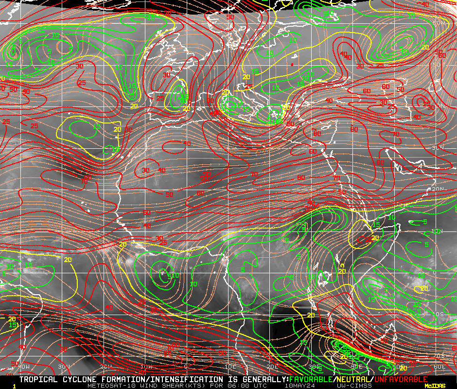
- No SAL between MCS and CV - JAC, 7/13/2010, 8:54 am
- Re: Large, High Cloud-Top MCS Hitting the Water - JAC, 7/13/2010, 7:37 am
- Re: Large, High Cloud-Top MCS Hitting the Water - BobbiStorm, 7/13/2010, 7:20 am
- Re: Models Honing in on CV Wave - BobbiStorm, 7/12/2010, 3:55 pm
- Re: Models Honing in on CV Wave - ricksterpr, 7/12/2010, 5:26 pm
- Re: Models Honing in on CV Wave - BobbiStorm, 7/12/2010, 7:15 pm
- take this test...go for it - BobbiStorm, 7/12/2010, 7:16 pm
- Tropical Gorilla - Doorman, 7/12/2010, 8:25 pm
- Re: Tropical Gorilla - Chris in Tampa, 7/12/2010, 9:23 pm
- Re: Tropical Gorilla - Doorman, 7/12/2010, 9:44 pm
- Re: Tropical Gorilla - BobbiStorm, 7/12/2010, 8:40 pm
- Re: Tropical Gorilla - Chris in Tampa, 7/12/2010, 9:23 pm
- Tropical Gorilla - Doorman, 7/12/2010, 8:25 pm
- take this test...go for it - BobbiStorm, 7/12/2010, 7:16 pm
- Re: Models Honing in on CV Wave - BobbiStorm, 7/12/2010, 7:15 pm
- Re: Models Honing in on CV Wave - ricksterpr, 7/12/2010, 5:26 pm
- Same scenario for CMC - JAC, 7/12/2010, 12:49 pm
- Euro - a bit later and more south - JAC, 7/12/2010, 12:47 pm
- Re: Euro - a bit later and more south - ArgosyTn, 7/12/2010, 2:06 pm
- Re: Euro - a bit later and more south - canetrakker, 7/12/2010, 2:45 pm
- Re: Euro - a bit later and more south - skip_wiley, 7/12/2010, 6:46 pm
- Re: Euro - a bit later and more south - JAC, 7/12/2010, 2:19 pm
- Re: Euro - a bit later and more south - ArgosyTn, 7/12/2010, 3:54 pm
- Re: Euro - a bit later and more south - canetrakker, 7/12/2010, 2:45 pm
- Re: Euro - a bit later and more south - ArgosyTn, 7/12/2010, 2:06 pm
Post A Reply
This thread has been archived and can no longer receive replies.