3:00 AM MDT Tue Oct 23
Posted by cypresstx on 10/23/2018, 6:53 am
| so I learned a word, it's been around since 1705, I guess I just never heard of it before ? or maybe I knew it & it's just the cold meds... https://www.nhc.noaa.gov/#Willa https://www.nhc.noaa.gov/refresh/graphics_ep4+shtml/083930.shtml?gm_track#contents https://www.ssd.noaa.gov/PS/TROP/storms/WILLA.html (floaters w/forecast points, I like) 3:00 AM MDT Tue Oct 23 Location: 20.8N 107.3W Moving: N at 5 mph Min pressure: 945 mb Max sustained: 130 mph Hurricane Willa Discussion Number 13 NWS National Hurricane Center Miami FL EP242018 300 AM MDT Tue Oct 23 2018 Willa's overall satellite presentation has continued to slowly degrade since the previous advisory, with the exception of a few brief attempts at redevelopment of an inner-core ring of deep convection. However, dry intrusions from the moat region between the larger outer eyewall and the smaller inner core have thus far prevented the reformation of an inner eyewall. Satellite intensity estimates have been steadily decreasing, and the advisory intensity is set at 115 kt, based on a average of the subjective T- and CI-numbers from TAFB and a UW-CIMSS ADT objective estimate of T6.0/115 kt. An Air Force Reserve Unit reconnaissance aircraft is scheduled to reconnoiter Hurricane Willa later this morning, providing more detailed intensity information. The initial motion estimate remains northward, but at a slower forward speed, or 360/04 kt. There are no significant changes to the previous track forecast or reasoning. Willa is expected to move slowly northward this morning around the western periphery of a deep-layer ridge located over central Mexico, and then recurve toward the north-northeast and northeast at a faster forward speed by this afternoon ahead of an approaching mid-latitude trough, with that motion continuing into this evening and Wednesday. The new NHC track forecast is near the eastern edge of the tightly packed guidance envelope, near the FSSE and GFS model tracks. There has been no microwave imagery since around 0100Z to provide information on the eyewall replacement cycle (ERC). However, conventional infrared satellite imagery suggests that the ERC is still ongoing based on the appearance of a partial moat or clear region in the northern semicircle of the inner core. Willa is currently moving over warmer and deeper water as indicated by upper-ocean heat content (UOHC) values greater than 50 units. This favorable ocean condition is expected to continue along the forecast track for another 12 hours or so, which could help to offset the weakening rate due to the gradual increase in the southwesterly wind shear. By 18 h, or just before landfall, the shear is forecast to increase to more than 20 kt and the warm water beneath the hurricane is expected to become more shallow, a combination that could lead to significant upwelling and weakening. However, the official intensity forecast follows the consensus of the various intensity models, keeping Willa's intensity near 100 kt at landfall, which is similar to the FSSE and HCCA corrected-consensus models. Despite the forecast decrease in the peak winds, Willa is expected to remain a dangerous major hurricane through landfall, bringing life-threatening storm surge, wind, and rainfall hazards to Las Islas Marias and portions of west-central and southwestern Mexico later today. After moving inland, Willa will rapidly weaken, with dissipation forecast by Wednesday over the high terrain of Mexico. However, deep moisture from the remnants of Willa is forecast to spread northeastward over northern Mexico and portions of Texas where a swath of heavy rainfall is expected midweek. Key Messages: 1. A life-threatening storm surge is expected today along the coasts of the Isla Marias, and along the coast of southern Sinaloa and Nayarit states in west-central and southwestern Mexico near the path of Willa. Residents should rush preparations to completion to protect life and property and follow any advice given by local officials. 2. Everyone in the Isla Marias, and within the hurricane warning area along the coast of west-central Mexico should prepare for life-threatening major hurricane winds associated with the core of Willa. Hurricane force winds will also extend inland across the mountainous areas of west-central Mexico as Willa moves inland. 3. Heavy rainfall from Willa is likely to produce life-threatening flash flooding and landslides over much of southwestern and west-central Mexico. FORECAST POSITIONS AND MAX WINDS INIT 23/0900Z 20.8N 107.3W 115 KT 130 MPH 12H 23/1800Z 22.0N 106.5W 100 KT 115 MPH 24H 24/0600Z 23.8N 104.5W 40 KT 45 MPH...INLAND 36H 24/1800Z 25.8N 102.3W 20 KT 25 MPH...POST-TROP/INLAND 48H 25/0600Z...DISSIPATED INLAND $$ Forecaster Stewart   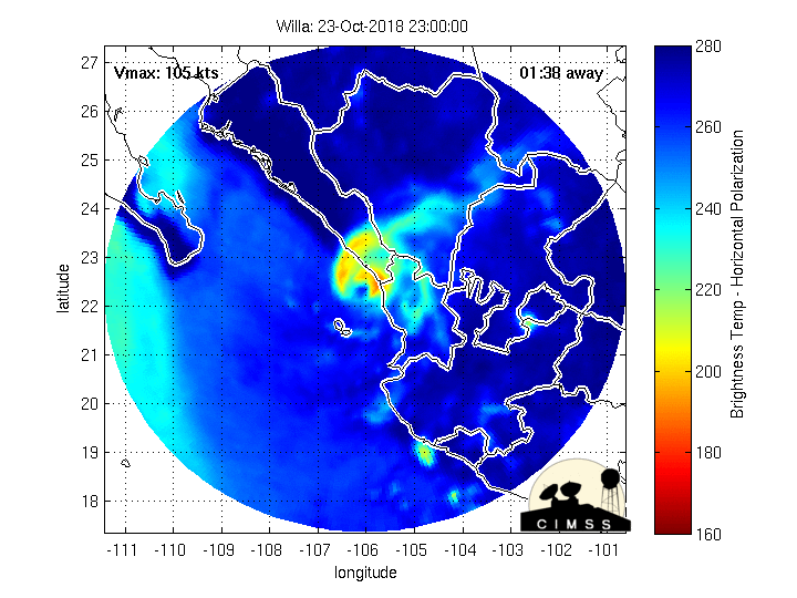 |
60
In this thread:
3:00 AM MDT Tue Oct 23 - cypresstx, 10/23/2018, 6:53 am
- Re: 3:00 AM MDT Tue Oct 23 - Chris in Tampa, 10/23/2018, 12:53 pm
- Recon images through 12:52pm EDT - Chris in Tampa, 10/23/2018, 1:07 pm
- Mazatlan, Tepic & Puerto Vallarta weather - cypresstx, 10/23/2018, 7:54 am
- GPM Flyby of Willa - cypresstx, 10/23/2018, 8:48 am
- core of dangerous Hurricane #Willa is expected to pass over Las Islas Marias, Mexico very soon - cypresstx, 10/23/2018, 8:50 am
- GPM Flyby of Willa - cypresstx, 10/23/2018, 8:48 am
< Return to the front page of the: message board | monthly archive this page is in
Post A Reply
This thread has been archived and can no longer receive replies.