this after over a foot of rain over Harlingen area in last days per MRMS
https://www.wpc.ncep.noaa.gov/metwatch/metwatch_mpd_multi.php?md=91&yr=2025
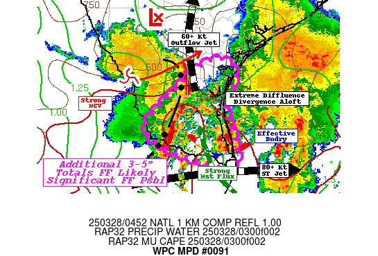
Mesoscale Precipitation Discussion 0091
NWS Weather Prediction Center College Park MD
1256 AM EDT Fri Mar 28 2025
Areas affected...Lower Rio Grande Valley and Lower Texas Gulf
Coast...
Concerning...Heavy rainfall...Flash flooding likely
Valid 280500Z - 281000Z
SUMMARY...Strong MCV, providing ascent for another round of strong
thunderstorms capable of 2"+/hr rates to further compound ongoing
significant flash flooding across the Rio Grande Valley. Heavy
rainfall likely to expand northward toward Corpus Christi urban
areas over the next few hours as well, with possible flash flooding
DISCUSSION...GOES-E WV shows strong vorticity center/MCV currently
along the south-southwest side of the larger scale stationary
upper-level low crossing over the Rio Grande into Webb county.
These height-falls have once again backed the low level flow off
the very moist/unstable western Gulf that had filtered across
Tamaulipas and into eastern Nuevo Leon state in Mexico. CIRA LPW
shows surface to boundary layer moisture nearing 1" fluxed on
30-35kts toward the flanking line, allowing for increased
instability of 1000-1500 J/kg (narrow and skinny profiles) while
this is leading to confluence through the ascent layer in the
850-500mb layer. CIRA LPW suggests an additional third to half
inch and quarter to third of an inch in those mid-levels to
support overall depth of 1.75 to near 2" along the Gulf coast. So
once again, strong moisture flux convergence aided by unstable air
has developed into a squall line with cells likely to increase
from 1.25 to 1.5-2"/hr as the line reaches deeper moisture further
east. Additionally, the southerly moist flow is expanding
scattered isentropically forced cells between the exiting
convective cluster and the approaching line. These more scattered
cells will be a tad shallower, but with solid flux should be still
prolific in rainfall capability even if more scattered/random in
nature...adding .5-1" prior to the main line. This WAA appears to
be trending northward toward relatively drier locations and may
start to stall/flatten to southwest steering as it nears the coast
across N Kenedy, Kleberg and Nueces county. Spots of 2-3" are
possible across this northern area that may initiate some
localized flash flooding concerns, especially near the Corpus
Christi urban areas that are particularly prone to intense rates.
Additionally, upper level jet diffluence remains extreme across
far southeast TX and the lower Rio Grande Valley with 60-70kt
speed max jet lifting northward across south Texas, while the core
of the sub-tropical jet streak is fairly flat (west to east)
across northeast Mexico into the Gulf. This is over 90 degrees of
diffluence maintaining solid evacuation of convection as it moves
eastward to areas already flooded. This should also allow for
slowing of forward propagation as well as with strengthening of
the low level inflow for flanking line back-building across the
Lower Rio Grande Valley. Additional 3-5" totals across already
flooded areas; likely to maintain flash flooding conditions with
some significant flash flooding/emergency conditions to be
possible with this next round. Localized totals over 10" are
likely to become reality across a broader area of lower Rio Grande
Valley.
While it is hopeful that after this MCV/forcing wave moves
through, the environment will clear out; however, there remains
quite a bit of uncertainty, as south-southeasterly flow of the
western Gulf is likely to be maintained through the peak of the
diurnal surge after prior to day break (08-10z). Intersection
with lingering outflow boundaries may still trigger additional
development, but will update the MPD later this morning to address
this concern.
Gallina
ATTN...WFO...BRO...CRP...
ATTN...RFC...WGRFC...NWC...
LAT...LON 28039762 27789713 27029738 26529721 25969710
25799726 25919782 26109845 26259881 26489914
26749915 27249867 27579831
|